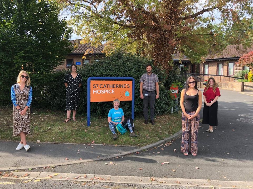
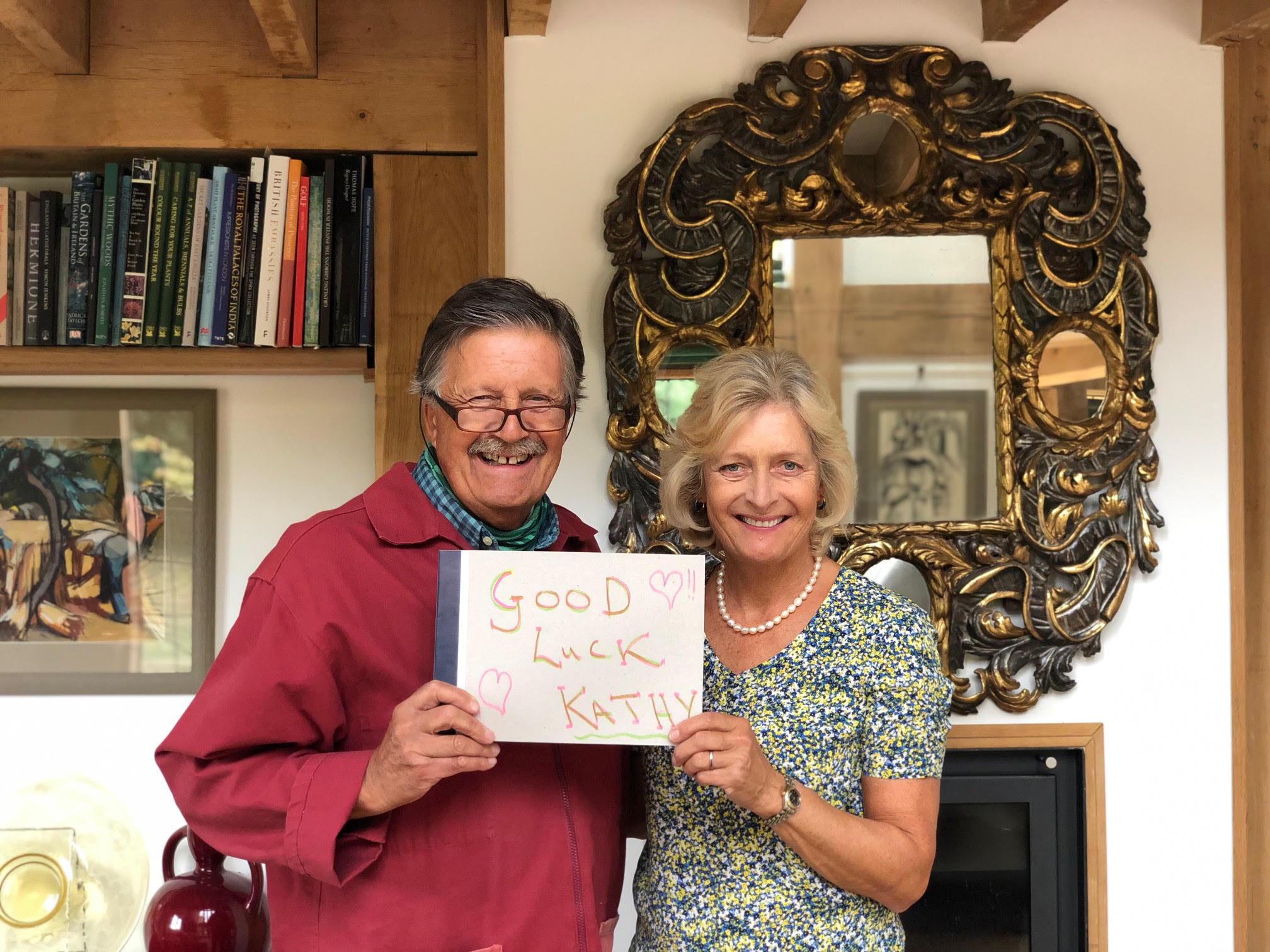
Before starting this section of the Trail, I called by St Catherine’s Hospice in Crawley and was greeted by (left to right) Hannah Liles – Income Generation Project Manager, Laura Kelly – Philanthropy Manager, Tom Abbott – Head of Fundraising, Suzanne Davis – Corporate Fundraiser and Michaela Clements – Events Fundraising Manager.
 We chatted about the impact Covid-19 has had on the hospice. As with many other hospices, inpatient occupancy was very low in the first few months of the pandemic; there was an increase in care delivered in the community, and a great deal of support given via telephone and video link. Inpatient numbers are returning to normal. Construction of the new hospice building at Pease Pottage, which should have commenced in June, has been delayed until it is deemed sensible to do so. In terms of fundraising – the hospice had an excellent response to its Covid appeal which raised £130k and is about to embark on a second. It costs around £10m a year to run all of St Catherine’s hospice services. A third of this is funded through NHS grants and contracts, with the remaining two-thirds being raised from the local community (shops, fundraising, lottery and legacies).
My day started somewhat disastrously – apart from my visit to St Catherine’s – and continued a little that vein throughout the day. Because I’ve used a huge amount of data on my iPhone – sending photos via text each day – O2 decided I’d gone way over my limit and cut me off!
They’d sent an email warning me and I had paid to cover this, but they still cut me off. This meant I had no means of communication and, much more worrying, no GPS – no ‘little blue dot’ – I could follow. I decided to go ahead armed with the guide notes. I could still take photos on my iPhone – I just couldn’t send them anywhere – and I could use the phone’s compass.
We chatted about the impact Covid-19 has had on the hospice. As with many other hospices, inpatient occupancy was very low in the first few months of the pandemic; there was an increase in care delivered in the community, and a great deal of support given via telephone and video link. Inpatient numbers are returning to normal. Construction of the new hospice building at Pease Pottage, which should have commenced in June, has been delayed until it is deemed sensible to do so. In terms of fundraising – the hospice had an excellent response to its Covid appeal which raised £130k and is about to embark on a second. It costs around £10m a year to run all of St Catherine’s hospice services. A third of this is funded through NHS grants and contracts, with the remaining two-thirds being raised from the local community (shops, fundraising, lottery and legacies).
My day started somewhat disastrously – apart from my visit to St Catherine’s – and continued a little that vein throughout the day. Because I’ve used a huge amount of data on my iPhone – sending photos via text each day – O2 decided I’d gone way over my limit and cut me off!
They’d sent an email warning me and I had paid to cover this, but they still cut me off. This meant I had no means of communication and, much more worrying, no GPS – no ‘little blue dot’ – I could follow. I decided to go ahead armed with the guide notes. I could still take photos on my iPhone – I just couldn’t send them anywhere – and I could use the phone’s compass.
 The weather was slightly overcast as I set off from Balcombe Station. I felt excited at the prospect of an adventure and only a smidgen of apprehension over my total lack of sense of direction. I also felt it would give me a good opportunity to really be alone to meditate and clear stuff – O2 had pushed a lot of buttons – so I had plenty to work on.
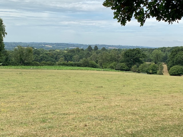
The guide notes promised some great views of the Sussex Weald from the top of the first hill but trees were blocking much of the view – I wondered if, when the walk was being tracked, the trees weren’t in leaf? This was more than compensated for throughout the walk as there were many, many fantastic panoramic vistas.
As I progressed I was pleased with how well I was doing, my confidence being boosted by the sight of our green Hospice Trail waymarkers at intervals and the sky was brightening up. I walked through farms, and fields and several very pretty woods and arrived without any problem at Ditton Place, an impressive Grade II listed building built in 1904 for the owner of Prudential Insurance who used the house as a summer residence.
On the edge of the estate was a very pretty house, it’s garden neatly planted with red geraniums. I was fascinated by the ‘City of London’ planters outside the front door – also planted with red geraniums – and wondered who lived there.
As I continued there were fabulous views across the High Weald – patchworks of greens and golds – truly breathtaking.On entering a delightful wood with the sun was breaking through the canopy in places, it brought to mind happy childhood memories of family outings to Epping Forest – we lived just off the busy Commercial Road/A13 in East London and Epping was only about an hour away.
It was after the next woodland section that I got horribly lost – possibly caused by my misinterpretation of the guide notes. I began to panic a bit and had gone a long way without seeing anything mentioned in the notes or a Trail waymarker and when I referred to my compass it told me I was heading east – 180 degrees in the wrong direction!
I knocked on the door of a cottage but there was no response and then flagged down a van. I explained what I was doing and asked the driver, a lovely man called Tony, if he could direct me to Nyman’s – my next point of reference. He said he’d never heard of Nyman’s as he’d just driven from Bournemouth but his Google map showed that it wasn’t too far away. We agreed the safest bet would be to make my way by the main roads and pick up the Trail from Nyman’s. Before driving off Tony handed me a twenty pound note for FSH – aren’t people wonderful!
This plan meant walking for over a mile along the busy B2114 which had no footpath or pavement….. quite scary in places. Rather stupidly I headed for where the Trail entered Nyman’s rather than where it exited, which meant an interesting but steep walk down through its woods and a very long schlep back up to the top again.
Relieved to be back on track and even more delighted to see the ‘nearest point to St Catherine’s Hospice’ way marker as I left Nyman’s, I headed off in the direction of Carterslodge Pond.
Crossing over the A23 via the B2110 was quite hair raising – I don’t have a good head for heights and the noise and speed of the traffic whizzing by underneath made me feel dizzy.
About a mile or so further on I went horribly wrong again – this time, I think, because signage and access to the public footpath had been removed and any trace was now covered in brambles. Using my compass I walked in a westerly direction as best I could. With the help of a cyclist, I eventually found the top of Carterslodge Lane and, at its bottom, Carterslodge Pond, where some major ground works were underway.
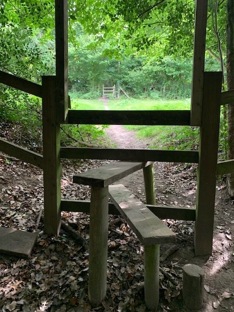
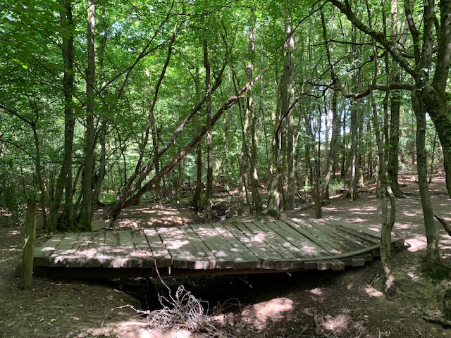
After a steady climb up from the pond I was led through a cornfield – with breathtaking views – and into some woods where a large footbridge over a stream had subsided – it was, however, stable enough to cross. From here I entered St Leonard’s Forest, an 85 hectare Forestry Commission-owned site. It’s path was wide and open with people perambulating along it. I was happily back on track, endorsed by a few more Hospice Trail waymarkers.
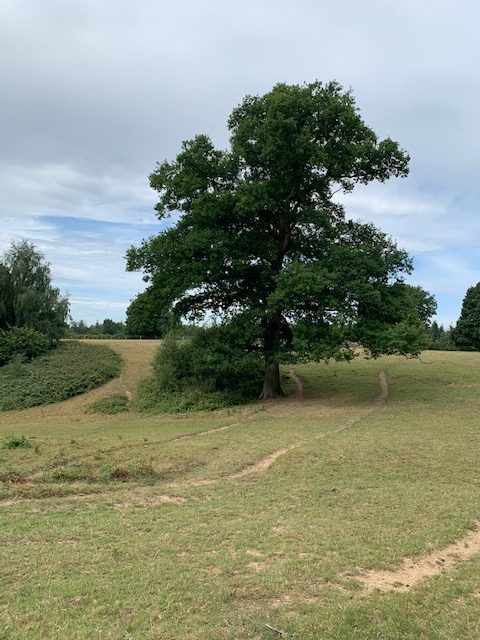
A woodland path led me out of the forest and onto a wide open space with no sign of the motocross bikes that my guide notes said often use it for racing. A little further on I reached the outskirts of Horsham and after about a mile of urban Horsham, eventually reached the station. It had taken me 6.5 hours and I had walked 14.1 miles (instead of 5.5 hours and 11 miles). I felt absolutely pooped but at the same time relieved and elated that I made it.
This was by far the toughest walk I’ve done on the trail so far, both physically and mentally. It put me outside my comfort zone on several occasions – which forced me to go within and to really feel and clear the feelings and emotions that arose. So it was meant to be. Today’s quote in my Buddhist book of thoughts read: “Western laziness consists of cramming our lives with compulsive activity, so that there is no time at all to confront the real issues”. Today I was given the time and space to do some of that.
This section of the trail was sponsored by Tim and Helen Wonnacott. Tim is a Patron of FSH and he believes that the many public footpaths in Sussex are one of the great joys of living in this county. I couldn’t agree more!
The weather was slightly overcast as I set off from Balcombe Station. I felt excited at the prospect of an adventure and only a smidgen of apprehension over my total lack of sense of direction. I also felt it would give me a good opportunity to really be alone to meditate and clear stuff – O2 had pushed a lot of buttons – so I had plenty to work on.
The guide notes promised some great views of the Sussex Weald from the top of the first hill but trees were blocking much of the view – I wondered if, when the walk was being tracked, the trees weren’t in leaf? This was more than compensated for throughout the walk as there were many, many fantastic panoramic vistas.
As I progressed I was pleased with how well I was doing, my confidence being boosted by the sight of our green Hospice Trail waymarkers at intervals and the sky was brightening up. I walked through farms, and fields and several very pretty woods and arrived without any problem at Ditton Place, an impressive Grade II listed building built in 1904 for the owner of Prudential Insurance who used the house as a summer residence.
On the edge of the estate was a very pretty house, it’s garden neatly planted with red geraniums. I was fascinated by the ‘City of London’ planters outside the front door – also planted with red geraniums – and wondered who lived there.
As I continued there were fabulous views across the High Weald – patchworks of greens and golds – truly breathtaking.On entering a delightful wood with the sun was breaking through the canopy in places, it brought to mind happy childhood memories of family outings to Epping Forest – we lived just off the busy Commercial Road/A13 in East London and Epping was only about an hour away.
It was after the next woodland section that I got horribly lost – possibly caused by my misinterpretation of the guide notes. I began to panic a bit and had gone a long way without seeing anything mentioned in the notes or a Trail waymarker and when I referred to my compass it told me I was heading east – 180 degrees in the wrong direction!
I knocked on the door of a cottage but there was no response and then flagged down a van. I explained what I was doing and asked the driver, a lovely man called Tony, if he could direct me to Nyman’s – my next point of reference. He said he’d never heard of Nyman’s as he’d just driven from Bournemouth but his Google map showed that it wasn’t too far away. We agreed the safest bet would be to make my way by the main roads and pick up the Trail from Nyman’s. Before driving off Tony handed me a twenty pound note for FSH – aren’t people wonderful!
This plan meant walking for over a mile along the busy B2114 which had no footpath or pavement….. quite scary in places. Rather stupidly I headed for where the Trail entered Nyman’s rather than where it exited, which meant an interesting but steep walk down through its woods and a very long schlep back up to the top again.
Relieved to be back on track and even more delighted to see the ‘nearest point to St Catherine’s Hospice’ way marker as I left Nyman’s, I headed off in the direction of Carterslodge Pond.
Crossing over the A23 via the B2110 was quite hair raising – I don’t have a good head for heights and the noise and speed of the traffic whizzing by underneath made me feel dizzy.
About a mile or so further on I went horribly wrong again – this time, I think, because signage and access to the public footpath had been removed and any trace was now covered in brambles. Using my compass I walked in a westerly direction as best I could. With the help of a cyclist, I eventually found the top of Carterslodge Lane and, at its bottom, Carterslodge Pond, where some major ground works were underway.
After a steady climb up from the pond I was led through a cornfield – with breathtaking views – and into some woods where a large footbridge over a stream had subsided – it was, however, stable enough to cross. From here I entered St Leonard’s Forest, an 85 hectare Forestry Commission-owned site. It’s path was wide and open with people perambulating along it. I was happily back on track, endorsed by a few more Hospice Trail waymarkers.
A woodland path led me out of the forest and onto a wide open space with no sign of the motocross bikes that my guide notes said often use it for racing. A little further on I reached the outskirts of Horsham and after about a mile of urban Horsham, eventually reached the station. It had taken me 6.5 hours and I had walked 14.1 miles (instead of 5.5 hours and 11 miles). I felt absolutely pooped but at the same time relieved and elated that I made it.
This was by far the toughest walk I’ve done on the trail so far, both physically and mentally. It put me outside my comfort zone on several occasions – which forced me to go within and to really feel and clear the feelings and emotions that arose. So it was meant to be. Today’s quote in my Buddhist book of thoughts read: “Western laziness consists of cramming our lives with compulsive activity, so that there is no time at all to confront the real issues”. Today I was given the time and space to do some of that.
This section of the trail was sponsored by Tim and Helen Wonnacott. Tim is a Patron of FSH and he believes that the many public footpaths in Sussex are one of the great joys of living in this county. I couldn’t agree more!
 We chatted about the impact Covid-19 has had on the hospice. As with many other hospices, inpatient occupancy was very low in the first few months of the pandemic; there was an increase in care delivered in the community, and a great deal of support given via telephone and video link. Inpatient numbers are returning to normal. Construction of the new hospice building at Pease Pottage, which should have commenced in June, has been delayed until it is deemed sensible to do so. In terms of fundraising – the hospice had an excellent response to its Covid appeal which raised £130k and is about to embark on a second. It costs around £10m a year to run all of St Catherine’s hospice services. A third of this is funded through NHS grants and contracts, with the remaining two-thirds being raised from the local community (shops, fundraising, lottery and legacies).
My day started somewhat disastrously – apart from my visit to St Catherine’s – and continued a little that vein throughout the day. Because I’ve used a huge amount of data on my iPhone – sending photos via text each day – O2 decided I’d gone way over my limit and cut me off!
They’d sent an email warning me and I had paid to cover this, but they still cut me off. This meant I had no means of communication and, much more worrying, no GPS – no ‘little blue dot’ – I could follow. I decided to go ahead armed with the guide notes. I could still take photos on my iPhone – I just couldn’t send them anywhere – and I could use the phone’s compass.
We chatted about the impact Covid-19 has had on the hospice. As with many other hospices, inpatient occupancy was very low in the first few months of the pandemic; there was an increase in care delivered in the community, and a great deal of support given via telephone and video link. Inpatient numbers are returning to normal. Construction of the new hospice building at Pease Pottage, which should have commenced in June, has been delayed until it is deemed sensible to do so. In terms of fundraising – the hospice had an excellent response to its Covid appeal which raised £130k and is about to embark on a second. It costs around £10m a year to run all of St Catherine’s hospice services. A third of this is funded through NHS grants and contracts, with the remaining two-thirds being raised from the local community (shops, fundraising, lottery and legacies).
My day started somewhat disastrously – apart from my visit to St Catherine’s – and continued a little that vein throughout the day. Because I’ve used a huge amount of data on my iPhone – sending photos via text each day – O2 decided I’d gone way over my limit and cut me off!
They’d sent an email warning me and I had paid to cover this, but they still cut me off. This meant I had no means of communication and, much more worrying, no GPS – no ‘little blue dot’ – I could follow. I decided to go ahead armed with the guide notes. I could still take photos on my iPhone – I just couldn’t send them anywhere – and I could use the phone’s compass.
 The weather was slightly overcast as I set off from Balcombe Station. I felt excited at the prospect of an adventure and only a smidgen of apprehension over my total lack of sense of direction. I also felt it would give me a good opportunity to really be alone to meditate and clear stuff – O2 had pushed a lot of buttons – so I had plenty to work on.
 The guide notes promised some great views of the Sussex Weald from the top of the first hill but trees were blocking much of the view – I wondered if, when the walk was being tracked, the trees weren’t in leaf? This was more than compensated for throughout the walk as there were many, many fantastic panoramic vistas.
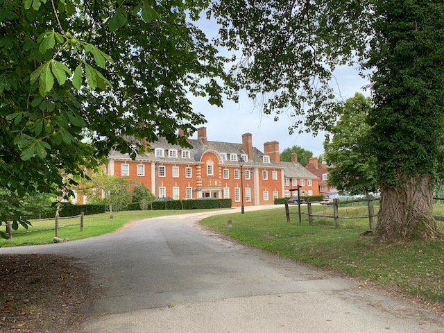 As I progressed I was pleased with how well I was doing, my confidence being boosted by the sight of our green Hospice Trail waymarkers at intervals and the sky was brightening up. I walked through farms, and fields and several very pretty woods and arrived without any problem at Ditton Place, an impressive Grade II listed building built in 1904 for the owner of Prudential Insurance who used the house as a summer residence.
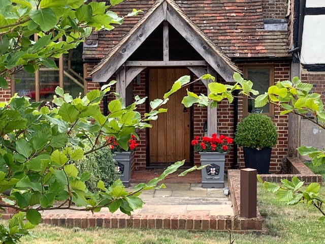 On the edge of the estate was a very pretty house, it’s garden neatly planted with red geraniums. I was fascinated by the ‘City of London’ planters outside the front door – also planted with red geraniums – and wondered who lived there.
 As I continued there were fabulous views across the High Weald – patchworks of greens and golds – truly breathtaking.On entering a delightful wood with the sun was breaking through the canopy in places, it brought to mind happy childhood memories of family outings to Epping Forest – we lived just off the busy Commercial Road/A13 in East London and Epping was only about an hour away.
It was after the next woodland section that I got horribly lost – possibly caused by my misinterpretation of the guide notes. I began to panic a bit and had gone a long way without seeing anything mentioned in the notes or a Trail waymarker and when I referred to my compass it told me I was heading east – 180 degrees in the wrong direction!
I knocked on the door of a cottage but there was no response and then flagged down a van. I explained what I was doing and asked the driver, a lovely man called Tony, if he could direct me to Nyman’s – my next point of reference. He said he’d never heard of Nyman’s as he’d just driven from Bournemouth but his Google map showed that it wasn’t too far away. We agreed the safest bet would be to make my way by the main roads and pick up the Trail from Nyman’s. Before driving off Tony handed me a twenty pound note for FSH – aren’t people wonderful!
This plan meant walking for over a mile along the busy B2114 which had no footpath or pavement….. quite scary in places. Rather stupidly I headed for where the Trail entered Nyman’s rather than where it exited, which meant an interesting but steep walk down through its woods and a very long schlep back up to the top again.
As I continued there were fabulous views across the High Weald – patchworks of greens and golds – truly breathtaking.On entering a delightful wood with the sun was breaking through the canopy in places, it brought to mind happy childhood memories of family outings to Epping Forest – we lived just off the busy Commercial Road/A13 in East London and Epping was only about an hour away.
It was after the next woodland section that I got horribly lost – possibly caused by my misinterpretation of the guide notes. I began to panic a bit and had gone a long way without seeing anything mentioned in the notes or a Trail waymarker and when I referred to my compass it told me I was heading east – 180 degrees in the wrong direction!
I knocked on the door of a cottage but there was no response and then flagged down a van. I explained what I was doing and asked the driver, a lovely man called Tony, if he could direct me to Nyman’s – my next point of reference. He said he’d never heard of Nyman’s as he’d just driven from Bournemouth but his Google map showed that it wasn’t too far away. We agreed the safest bet would be to make my way by the main roads and pick up the Trail from Nyman’s. Before driving off Tony handed me a twenty pound note for FSH – aren’t people wonderful!
This plan meant walking for over a mile along the busy B2114 which had no footpath or pavement….. quite scary in places. Rather stupidly I headed for where the Trail entered Nyman’s rather than where it exited, which meant an interesting but steep walk down through its woods and a very long schlep back up to the top again.
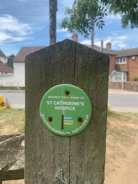 Relieved to be back on track and even more delighted to see the ‘nearest point to St Catherine’s Hospice’ way marker as I left Nyman’s, I headed off in the direction of Carterslodge Pond.
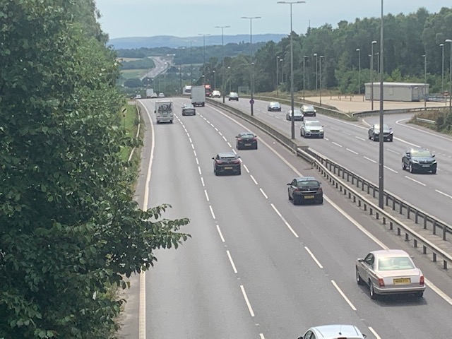 Crossing over the A23 via the B2110 was quite hair raising – I don’t have a good head for heights and the noise and speed of the traffic whizzing by underneath made me feel dizzy.
 About a mile or so further on I went horribly wrong again – this time, I think, because signage and access to the public footpath had been removed and any trace was now covered in brambles. Using my compass I walked in a westerly direction as best I could. With the help of a cyclist, I eventually found the top of Carterslodge Lane and, at its bottom, Carterslodge Pond, where some major ground works were underway.
After a steady climb up from the pond I was led through a cornfield – with breathtaking views – and into some woods where a large footbridge over a stream had subsided – it was, however, stable enough to cross. From here I entered St Leonard’s Forest, an 85 hectare Forestry Commission-owned site. It’s path was wide and open with people perambulating along it. I was happily back on track, endorsed by a few more Hospice Trail waymarkers.
A woodland path led me out of the forest and onto a wide open space with no sign of the motocross bikes that my guide notes said often use it for racing. A little further on I reached the outskirts of Horsham and after about a mile of urban Horsham, eventually reached the station. It had taken me 6.5 hours and I had walked 14.1 miles (instead of 5.5 hours and 11 miles). I felt absolutely pooped but at the same time relieved and elated that I made it.
This was by far the toughest walk I’ve done on the trail so far, both physically and mentally. It put me outside my comfort zone on several occasions – which forced me to go within and to really feel and clear the feelings and emotions that arose. So it was meant to be. Today’s quote in my Buddhist book of thoughts read: “Western laziness consists of cramming our lives with compulsive activity, so that there is no time at all to confront the real issues”. Today I was given the time and space to do some of that.
About a mile or so further on I went horribly wrong again – this time, I think, because signage and access to the public footpath had been removed and any trace was now covered in brambles. Using my compass I walked in a westerly direction as best I could. With the help of a cyclist, I eventually found the top of Carterslodge Lane and, at its bottom, Carterslodge Pond, where some major ground works were underway.
After a steady climb up from the pond I was led through a cornfield – with breathtaking views – and into some woods where a large footbridge over a stream had subsided – it was, however, stable enough to cross. From here I entered St Leonard’s Forest, an 85 hectare Forestry Commission-owned site. It’s path was wide and open with people perambulating along it. I was happily back on track, endorsed by a few more Hospice Trail waymarkers.
A woodland path led me out of the forest and onto a wide open space with no sign of the motocross bikes that my guide notes said often use it for racing. A little further on I reached the outskirts of Horsham and after about a mile of urban Horsham, eventually reached the station. It had taken me 6.5 hours and I had walked 14.1 miles (instead of 5.5 hours and 11 miles). I felt absolutely pooped but at the same time relieved and elated that I made it.
This was by far the toughest walk I’ve done on the trail so far, both physically and mentally. It put me outside my comfort zone on several occasions – which forced me to go within and to really feel and clear the feelings and emotions that arose. So it was meant to be. Today’s quote in my Buddhist book of thoughts read: “Western laziness consists of cramming our lives with compulsive activity, so that there is no time at all to confront the real issues”. Today I was given the time and space to do some of that.
 This section of the trail was sponsored by Tim and Helen Wonnacott. Tim is a Patron of FSH and he believes that the many public footpaths in Sussex are one of the great joys of living in this county. I couldn’t agree more!